

LSU, State Meet Growing U.S. Demand for Storm Surge and Flood Predictions
March 07, 2023
With support from the Louisiana Legislature, LSU is increasing the capacity of one of its most in-demand tools to protect coastal communities from flooding and storm surge while adding operational relevance to the science that supports it.
LSU’s CERA website predicted 10 feet of storm surge in the city of Fort Myers, Florida, even before Hurricane Ian had reached Cuba. The prediction was later confirmed by NOAA water gauges.
Before Hurricane Ian made landfall in southwest Florida last September as the deadliest hurricane to strike the state since 1935, emergency managers across the nation turned to LSU. On a single day, LSU’s Coastal Emergency Risk Assessment website, or CERA, which maps storm surge and flood predictions, received three million internet requests as people tried to decide what to do and how to prepare. The demand got so high that it pushed CERA’s network connection to the limit.
“It’s a good problem to have, in a way, to have become such an essential resource that you’re pushed to the max,” said Carola Kaiser, CERA team leader at the LSU Center for Computation & Technology, or CCT. “But it also became clear that we have to rise to the challenge of the growing demands on our systems since we always have to be able to provide first responders and decision-makers in Louisiana with the critical information they’ve come to rely on.”
With $250K in support from the state, CCT is now adding 10 times the current networking capacity for CERA, as well as extra power backups so the servers can keep working even if there’s a widespread outage, advanced cooling for the data center that houses the servers (again, despite a possible power outage), and up to two petabytes of additional data storage. All to ensure continuous and sustained operations.
“We need a lot of compute power to run our models and produce the results people see on the CERA website, and we must be able to offload and store that data quickly to get ready to run our models again,” Kaiser said.
Ahead of Hurricane Ian, CERA provided five separate track scenarios to the public and professional users, who have access to even more detailed information, in every U.S. state. New pro login requests arrived from the U.S. Coast Guard and Marine Corps, FEMA, the Department of Defense and the Department of Homeland Security as well as others.
Before the storm had even reached Cuba, CERA predicted 10 feet of storm surge in the city of Fort Meyers, Florida, a prediction that was later confirmed by National Oceanic and Atmospheric Administration, or NOAA, water gauges.
While CERA is LSU’s operational and public face of storm surge and flood modeling, university researchers are also advancing the underlying science that supports outputs like CERA.
Z. George Xue, associate professor in the LSU Department of Oceanography & Coastal Sciences with a joint appointment in the LSU Center for Computation & Technology, recently developed a new and dynamically coupled two-way flood model based on historical data from Hurricane Florence in 2018, which caused a lot of compound flooding in the Cape Fear estuary in North Carolina. Compound flooding is when water combines from at least two different sources—in this case, storm surge from the ocean and rain, runoff and river flooding from the land. Xue was able to show 20-40 percent better accuracy than the current state-of-the-art, which is a one-way coupled model where the output of one (usually the river) is fed back into the other (usually the ocean), so the models run sequentially.
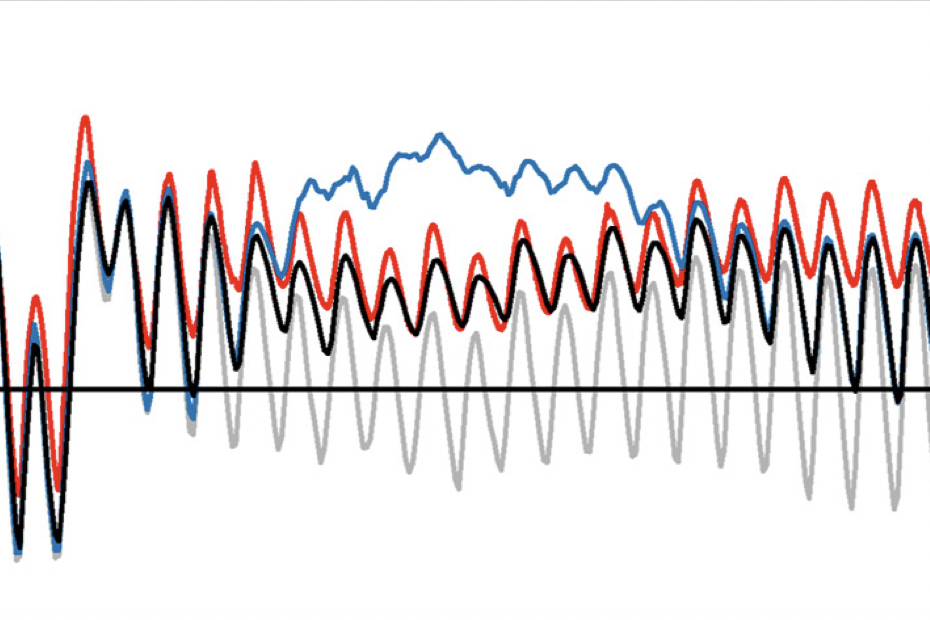
Comparison of water levels between observed, real data (red), stand‐alone flood modeling results (gray, an underestimate), linked modeling results (blue, an overestimate) and dynamically coupled modeling results using George Xue’s COAWST model (black) at a NOAA station in the Cape Fear estuary in North Carolina during Hurricane Florence in 2018.
“Our model is different,” Xue said. “We run both the ocean model and the river model in parallel to dynamically represent the exchange of water in the land-ocean interaction zone. The models talk on their boundary to continuously recreate the conditions of the compound flooding event, so there’s no set boundary condition.”
With initial support from United States Geological Survey, NOAA, and $200K from the Louisiana Legislature, Xue’s research group has become more competitive for computational grants related to floods and severe storms. Xue was recently awarded an additional $1.4 million from NASA and $343K—part of a larger project with the University of Florida—from the Office of Naval Research as part of the National Oceanographic Partnership Program. The goal of these new projects is to put his team’s model, called Coupled-Ocean-Atmosphere-Wave-Sediment-Transport, or COAWST, to the test along the Gulf Coast: in Barataria Bay in Louisiana and in Galveston Bay and Port Aransas in Texas. He also plans to develop versions of the model for different parts of the Louisiana coast. His team will investigate what it would take to transform their research model into an operational model, where it could be used within the context of an active storm. As the LSU CERA team knows, this significantly raises the bar for performance.
“We don’t yet know the computational cost, how fast we can run our model, or what kind of resolution we can afford; these are big unknowns,” Xue said. “We can’t spend 10 days creating a high-accuracy forecast at the moment a hurricane is coming. But using the state funds, we’ll be able to test our model’s performance in different environments and locations in Louisiana to make it more useful.”
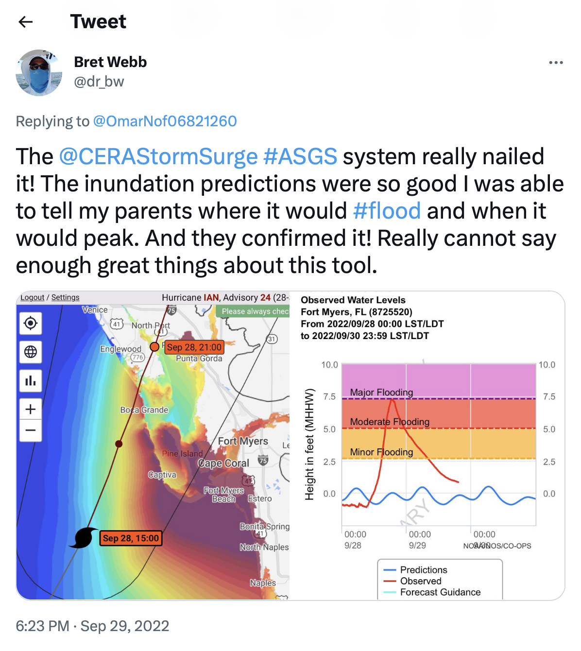
CERA received three million internet requests in a single day ahead of Hurricane Ian last year as people tried to decide what to do and how to prepare.
Xue will spend most of the money from the state to support his graduate students and a new research assistant professor at CCT, Zhengchen Zang, who was Xue’s first Ph.D. student in oceanography to graduate from LSU to then pursue a postdoc at Woods Hole, one of the world’s leading oceanographic institutions. Zang’s expertise lies in numerical modeling, primarily of sediment on Louisiana’s continental shelf, far out in the Gulf of Mexico, and further inland. He studies how hurricanes can greatly alter water depth, direction and speed by pushing sediment around and creating something called “fluid mud,” when lots of sediment gets suspended in the water and can begin to move like an underwater mudslide, with impacts on offshore energy infrastructure, such as rigs, wells and pipelines.
While Xue’s group relies entirely on NOAA data for their models and predictions, CERA relies on NOAA data combined with elevation data from Louisiana’s Coastal Protection and Restoration Authority, or CPRA, which has a contract with LSU, and input from CE Hydro, a local firm that helps CERA account for rainfall in the watersheds around Lake Pontchartrain, north of New Orleans and east of Baton Rouge, to more accurately capture compound flooding in some of the state’s most populated areas.
Many of the decisions on how to act based on the increasingly detailed information shared by CERA are made by individual levee districts and floodgate operators, such as Reggie Dupre, executive director of the Terrebonne Levee & Conservation District.
“In the last few years, LSU’s CERA has been an extremely valuable tool in assisting emergency managers in making critical decisions for emergencies due to hurricanes and tropical storms,” Dupre said. “CERA’s modeling information, sent to us by CPRA, not only predicts surges based on the National Hurricane Center’s predicted path, but also provides surge information based on a western, left, or eastern, right, shift in the landfall within the ‘cone of uncertainty.’ It provides us with surge modeling at several key locations along Louisiana’s coast.”
“One of these locations is the Houma Navigation Canal ‘Bubba Dove’ Floodgate in southern Terrebonne Parish,” Dupre continued. “In the past few years, we have verified CERA’s projections against the actual surge data at the Bubba Dove Floodgate. We have found that LSU’s CERA modeling, along with input from CPRA staff, is absolutely the most accurate and reliable information available to us.”
Read more:
- LSU Improves Storm Surge and Flood Predictions with AI (LSU)
- Coupled Computer Modeling Can Help More Accurately Predict Coastal Flooding, Study Demonstrates (LSU College of the Coast & Environment)
- LSU Partnerships Improve Hurricane Storm Surge Forecasts for Louisiana, Nation (LSU Office of Research & Economic Development)