

Tangipahoa’s Big Idea: LSU Helps Flood-Prone Louisiana Parish Rise to Challenges
July 01, 2021
Reducing Flood Risk in Tangipahoa Parish
In the wake of the 2016 floods, which devastated not just Tangipahoa Parish but turned 21 south Louisiana parishes into federal disaster areas, faculty and students in the LSU Coastal Sustainability Studio and LSU Department of Civil & Environmental Engineering began collaborating with local government and communities to set Tangipahoa Parish on a path toward resilience.
LSU deployed eight teams of senior-level hydrologic design students. They looked at specific engineering solutions, such as building a big reservoir up north; smaller reservoirs along the I-55 corridor and tributaries; and various flood mitigation strategies in the southern part of the parish, where most of the population lives—around Hammond and Ponchatoula, near the I-12, where both the landscape and the Tangipahoa River flatten out. It’s a transition zone where wind-driven storm surge can raise the water levels in Lake Pontchartrain, causing compound flooding problems when water from rainfall backs up all over the parish as it’s prevented from getting into the tributaries, into the main river, and into the lake.
But rather than just solving a flooding problem—that is, an engineering problem—LSU saw an opportunity to also improve neighborhoods, transportation, recreation, public health, and economic development throughout the parish. This meant working closely with local communities.
“It takes an enormous amount of education and science to even start having conversations about a project this size, and that’s what LSU helped us with,” said Tangipahoa Parish President Robby Miller.
Miller has overseen more disaster declarations in the five years he’s been in office than his predecessor did in his 29 years as parish president combined. Most of them have been related to floods.
Dana Brown & Associates, a landscape architecture and planning firm based in New Orleans, is now building on LSU’s work.
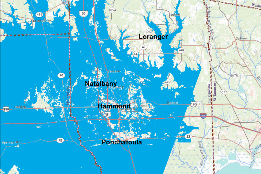
Estimated extent of flooding in Tangipahoa Parish in August 2016. Note how the areas near I-12 and the cities of Hammond and Ponchatoula are almost completely blue. The straight line on the right does not indicate that flooding stopped here; it’s simply where the flood model stopped.
– DeWitt H. Braud/LSU based on USGS and Dewberry flood data
“Our people have anxiety related to storms and flooding, and that’s understandable. Entire communities relocated here from St. Bernard Parish after Hurricane Katrina and thought they’d be safe. To decrease flood risk across our parish, LSU has helped us evaluate our antiquated ordinances and prioritize solutions that both would have the support of the community and be something we could actually do, and enforce. LSU helped us turn something that could seem a bit pie-in-the-sky into something actionable and achievable.”
Bridget Bailey, director of community development in Tangipahoa Parish