Tangipahoa’s Big Idea: LSU Helps Flood-Prone Louisiana Parish Rise to Challenges
July 01, 2021
March 28, 2022—UPDATE—$3.2 million in funding for an Army Corp of Engineers feasibility study for a Tangipahoa River reservoir as a stormwater management solution was included in the 2022 Disaster Relief Supplemental Appropriations Act.
In the wake of the 2016 floods, which devastated not just Tangipahoa Parish but turned 21 South Louisiana parishes into federal disaster areas, faculty and students in the LSU Coastal Sustainability Studio and LSU Department of Civil & Environmental Engineering began collaborating with local government and communities to set Tangipahoa Parish on a path toward resilience by changing rules and regulations and developing flood mitigation solutions, including reservoirs.
Tangipahoa Parish President Robby Miller got his idea of building a big reservoir in northern Tangipahoa from the Ross Barnett Reservoir on the Pearl River near Jackson, Mississippi, which not only has reduced flooding problems in the lower parts of the state, but also attracted millions of people to fish, camp, and enjoy the outdoors, bringing revenue and new business opportunities to the area.
Stretching all the way from Lake Pontchartrain to the Mississippi state line, Tangipahoa Parish is home to about 90% of the Louisiana portion of the Tangipahoa River, whose watershed drains most of the parish from north to south. Hammered by rain during Hurricane Isaac in 2012 and then twice in the spring and summer of 2016, as many as 5,000 residents saw their homes flooded three times in five years. In August of 2016, almost half of the parish flooded, as the Tangipahoa River rose more than 12 feet above flood stage.
New in office at the time was Parish President Robby Miller. He was, admittedly, not an expert on flood water management. Seeing the economic and emotional fallout for flooded businesses and communities, however, he wanted to do something—something big that would protect the parish in the long term, even if he likely wouldn’t be in office anymore once his “big idea” came to fruition.
Miller wanted to build a reservoir. He’d recently been to Ross Barnett on the Pearl River in Mississippi and seen how the 33,000-acre man-made lake not only had become the state’s largest source of drinking water, but also prevented the capital city of Jackson and the lower parts of the state from flooding while attracting millions of people to fish, camp, and enjoy the outdoors, bringing revenue and new business opportunities to the area. But how could they do something similar in Tangipahoa? How would they even start? And most importantly, would it work?
“We had this crazy idea and it really started to take shape at LSU.”
Tangipahoa Parish President Robby Miller
In the wake of the 2016 floods, which devastated not just Tangipahoa but turned 21
South Louisiana parishes into federal disaster areas, the LSU Coastal Sustainability
Studio invited Louisiana mayors and parish presidents to a workshop, part of their
Louisiana Community Resilience Institute. The workshop was modeled on a national initiative called the Mayors’ Institute on
City Design, supported by the National Endowment for the Arts, to help transform communities
through holistic design. The Studio’s goal was to refine and advance Louisiana decision-makers’
ideas to solve flooding problems across the state while also improving neighborhoods,
transportation, recreation, public health, economic development, etc. While LSU is
home to hundreds of experts in engineering, science, and design—and the #1 landscape
architecture program in the nation—units like the LSU Coastal Sustainability Studio
help bring all of this expertise together to take on challenges none of the individual
disciplines really could tackle on their own.
Miller brought his reservoir idea to the LSU workshop.
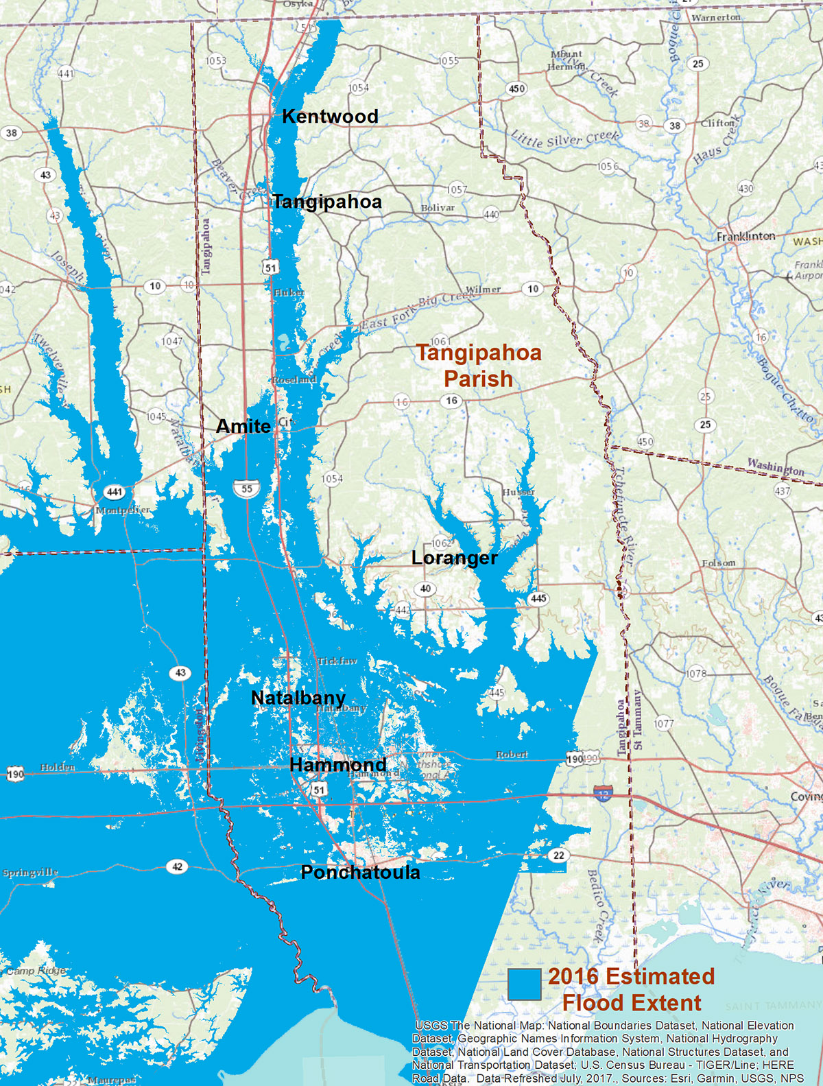
Estimated extent of flooding in Tangipahoa Parish in August 2016. Note how the areas near I-12 and the cities of Hammond and Ponchatoula are almost completely blue. The straight line on the right does not indicate that flooding stopped here; it’s simply where the flood model stopped.
– DeWitt H. Braud/LSU based on USGS and Dewberry flood data
“We had this crazy idea and it really started to take shape at that workshop at LSU,” Miller said. “LSU’s work gave us the first real science that said there was a good possibility our idea could work, that a reservoir could do what we needed it to do.”
“So, LSU faculty and students got to work on this and held community meetings in our
parish and conducted feasibility studies that not only confirmed our idea but came
up with additional solutions, like, instead of one, giant reservoir up in the north,
we could build several smaller reservoirs along the Tangipahoa River and get more
benefit,” Miller continued. “But while LSU worked on this for a year and a half or
two years, we never talked about the reservoir outside the office, we kept it hush-hush
because it was such an abstract and big idea until LSU confirmed it actually could
do something to help us with our flooding problem.”
Miller was concerned rumors would start flying about the parish government trying
to take people’s land to build reservoirs, among other things.
“It takes an enormous amount of education and science to even start having conversations about a project this size, and that’s what LSU helped us with.”
Robby Miller
“We didn’t need anybody to start panicking,” Miller said. “We were not about to take anyone’s land or make anybody move, but it’s easy for rumors to start flying, and then you spend more time trying to shut down the misinformation instead of talking about what you want to do and all the positives. It takes an enormous amount of education and science to even start having conversations about a project this size, and that’s what LSU helped us with.”
While Traci Birch, interim managing director of the LSU Coastal Sustainability Studio and assistant professor in the LSU School of Architecture, engaged communities in Tangipahoa Parish to make sure their concerns and desires became part of the proposed design, Clint Willson, director of the LSU Center for River Studies and professor in the LSU Department of Civil & Environmental Engineering, deployed eight teams of senior-level hydrologic design students to take a watershed approach to the issues in Tangipahoa Parish. They looked at specific engineering solutions, such as building a big reservoir up north; smaller reservoirs along the I-55 corridor and tributaries; and various flood mitigation strategies in the southern part of the parish, where most of the population lives, around Hammond and Ponchatoula near the I-12, where both the landscape and the Tangipahoa River flatten out. It’s a transition zone where wind-driven storm surge can raise the water levels in Lake Pontchartrain, causing compound flooding problems when water from rainfall backs up all over the parish as it’s prevented from getting into the tributaries, into the main river, and into the lake.
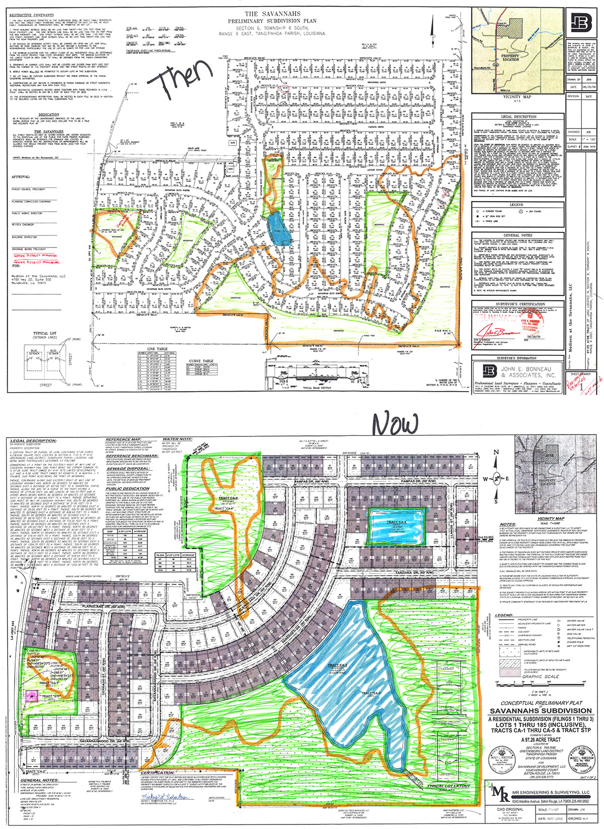
Before/after. The LSU Coastal Sustainability Studio worked with Tangipahoa Parish to evaluate and change their rules and regulations for new developments to prevent flooding. Existing wetlands are outlined in orange marker. Under the revised rules, at least 85% of wetlands are preserved, which means flood water has somewhere to go while residents gain functional greenspace.
– Drawings courtesy of Tangipahoa Parish
“The students had to identify problems by working with the stakeholders and the community and then identify potential solutions,” Willson said. “Student after student would eventually come back to me and say, ‘Is this really what I’m supposed to do?’ referring to what they were working on, and I’d go, ‘Don’t ask me—ask them! They’re the client…’ And sometimes the students would go, ‘The client wants this solution, but we don’t think it’s going to work…,’ and I’d go, ‘Well, part of your job is educating the client on what’s doable.’ There’s always more than one way to solve a problem in the real world, and that’s something our students really got to experience in Tangipahoa.”
“There’s always more than one way to solve a problem in the real world, and that’s something our students really got to experience in Tangipahoa.”
Clint Willson, director of the LSU Center for River Studies and professor in the LSU Department of Civil & Environmental Engineering
The students learned so much from working on flood mitigation solutions in Tangipahoa, in fact, that it changed how Willson and his colleagues, including Nicholas Serrano, assistant professor of landscape architecture, would manage student projects from then on.
“Since Tangipahoa, we’ve kept doing projects that are place-based—real solutions for real communities,” Willson explained. “We’ve followed the same model in our collaborations with the Department of Transportation and Development on flooding on I-110 near the Governor’s Mansion, in evaluating the use of neutral grounds for stormwater storage with the New Orleans Sewerage & Water Board, incorporating green infrastructure in Baker and Denham Springs, working with LSU landscape architecture students on the Baton Roots urban garden project, and evaluating stormwater mitigation projects along Plank Road, as envisioned by Build Baton Rouge as part of the Bus Rapid Transit project.”
“It was also thanks to LSU we got the Silver Jackets group from the Army Corps of Engineers to engage in Tangipahoa, so that was another major plus for us.”
Robby Miller
“When we saw the students’ final presentations, we were like, ‘Wow, these are students!’ and also, ‘Right, they’re students…,’” Miller said. “Some definitely got farther than others, but they all put in a ton of effort and a lot of research and we still use their data in our conversations with people and to go after funding to move these ideas closer to reality, which takes a long time. It was also thanks to LSU we got the Silver Jackets group from the Army Corps of Engineers to engage in Tangipahoa, so that was another major plus for us.”
Silver Jackets are teams that bring together state, federal, and sometimes tribal and local agencies to learn from one another in reducing flood risk. By applying their shared knowledge, the teams enhance response and recovery efforts related to natural disasters.
“We’re right now trying to pass on the data we got from LSU and educate our communities in how water moves and how flash flooding works, for example,” Miller said. “Having a reservoir upstream won’t necessarily help if you get 24 inches of rain on top of your head in less than 24 hours like we did in 2016. It takes time for that water to dissipate and sometimes the only fix is to raise your house to keep the water from getting to you again.”
“And, as you can imagine, that can be a tough answer to give,” Miller continued. “But I don’t think there’s anyone I can walk up to in Tangipahoa who wouldn’t agree with me that the rain and weather patterns we have now are different from how they used to be, when I was growing up. Just the amounts of rain we get. And I think most people are starting to understand that difference means we have to also do something different, and get ahead of this, for the future of our parish.”
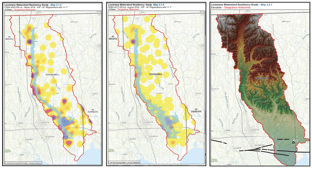
Flood insurance claim density in Tangipahoa Parish after the 2016 March and August floods and an elevation map of the Tangipahoa River watershed, which drains most of the parish all the way from the Mississippi state line into Lake Pontchartrain, north to south.
– Figures courtesy of LSU civil engineering students and now-graduates Patrick Downs, Matthew Riddlebarger, Owen Bouchon, Joshua DeLee, and Carson Rigol (CE 4260 Group 1, Spring 2018)
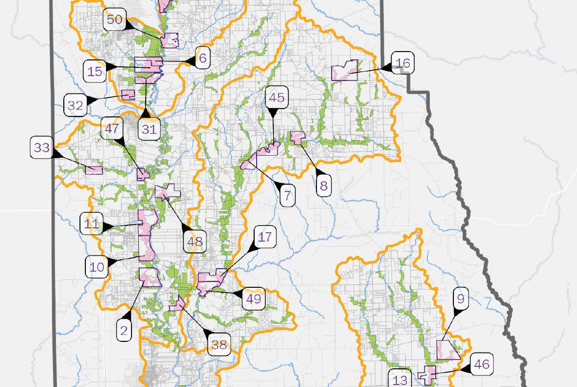
Miller has overseen more disaster declarations in the five years he’s been in office than his predecessor did in his 29 years as parish president combined. Most of them have been related to floods. There are still no major flood control structures in the parish, which is divided into three drainage districts, each with its own tax rates, as well as a fourth area managed by the parish. Instead of consolidating the districts, LSU, Traci Birch, and the Coastal Sustainability Studio recommended the parish engage all districts to establish the same rules and regulations.
“LSU helped us evaluate our antiquated ordinances and prioritize solutions that both would have the support of the community and be something we could actually do, and enforce.”
Bridget Bailey, director of community development in Tangipahoa Parish
“We had four different measuring sticks and now we’re at least down to two, and that’s made a huge difference,” said Bridget Bailey, director of community development in Tangipahoa Parish, who works with Miller. “We’ve gone from requiring 10- to 25-year rain event detention standards to 100-year rain event detention standards for new developments in 85% of the parish. We also changed our requirement of 1.5% of green space for new developments to 15%, and large subdivisions now have to preserve 85% of existing wetlands, which makes for much more effective stormwater management. LSU helped us evaluate our antiquated ordinances and prioritize solutions that both would have the support of the community and be something we could actually do, and enforce. After all, a plan is not worth anything if it just sits on a shelf.”
“Most importantly, LSU helped us turn something that could seem a bit pie-in-the-sky into something actionable and achievable,” Bailey continued. “Mapping a watershed in its entirety is a huge undertaking, but LSU got the ball rolling for us and helped us come up with action steps, like baby steps, to break it down so we can keep working toward our goal.”
When it starts raining hard in Tangipahoa Parish, Bailey gets phone calls.
“Our people have anxiety after going through two 500-year rain events in five months in 2016, and that’s understandable,” she said. “Entire communities relocated here from St. Bernard Parish after Hurricane Katrina and thought they’d be safe. Some people had just fixed up their homes and moved back in after getting 6-8 inches of water in March, and then got 4-5 feet of water in August.”
Despite its challenges, Traci Birch and the LSU Coastal Sustainability Studio recognize the parish also has a major advantage in rising to those challenges since almost the entire Tangipahoa River is within its purview.
“It’s not like the Amite River, which runs through multiple jurisdictions, and you’d have to politically try to get people to agree to spend money to build something in one place that benefits people somewhere else,” Birch said.
Dana Brown & Associates, a New Orleans landscape architecture firm, are building on the work LSU civil engineering students started to evaluate subwatersheds in Tangipahoa Parish. Instead of just building a giant reservoir up north, several smaller reservoirs could provide more benefit.
– Figure courtesy of Dana Brown & Associates
Birch, Willson, Miller, and Bailey have also all been working closely with Dana Brown & Associates, a landscape architecture and planning firm based in New Orleans.
“We’ve been able to use the results and modeling LSU did and build on that work,” said Dana Brown, who is an LSU landscape architecture alum. “The stormwater modeling that Clint Willson and his students did helped us evaluate 10 different areas in the middle of the parish that are some of the lowest points within their subwatersheds and situated to hold a lot of water. It’s all about where you get the biggest bang for your buck in terms of reducing flood risk. Of course, you can’t say you reduce flooding, you reduce flood risk. You never know how much rain you’re going to have tomorrow, and we need to be honest about how complex and difficult the conditions are. But by designing with nature instead of pretending it’s a blank slate, you can reduce flood risk while also preserving and protecting the natural environment that makes Tangipahoa such a beautiful place to live.”
“LSU showed us some things that were missing and where we could start implementing projects much sooner.”
Dana Brown of the New Orleans landscape architecture and planning firm Dana Brown & Associates
Through LSU’s and Dana Brown’s work, the parish now allows no more than a two-foot change in elevation from grading for new developments, which traditionally involves cutting down trees and leveling land using bulldozers, often disrupting the natural hydrology, how water drains and moves over land.
“You don’t have to look at every detail of the basin to know beneficial places to store water, and while we work toward solutions for the entire watershed, which takes a long time, LSU showed us some things that were missing and where we could start implementing projects much sooner,” Brown said.
“I’m fully aware, since we have term limits now, that I won’t be here, in office, once a reservoir actually gets built—maybe by the same LSU students we already worked with, but when they’ll be working for engineering firms,” Miller said. “It’s daunting, sometimes, to think about the money and everything it’s going to take to build infrastructure of this scale—it’s a huge collaboration—and I’m very grateful for the visuals and maps LSU put together for us, so we really could see it—how it could work, what it will look like. Everything else is kind of in my imagination.”
This news story was featured in LSU’s free, quarterly research publication, Working for Louisiana, where you can learn more about how work on every LSU campus impacts residents and industry in the state, and beyond.