
AI's Role in Protecting Louisiana's Environment
July 20, 2026
Chapter 2 of this series covers six environmental research programs. Each addresses a problem that directly affects Louisiana. I have tried to describe what we built, how it performed, and why it matters here, without overstating what the results show.
Reading Louisiana From Space
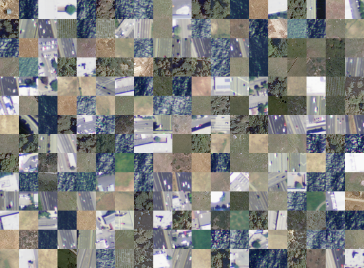
One of the images used to train the DeepSAT system.
Satellites provide broad, frequently updated observations of Earth's surface. Until recently, the data arrived faster than analysts could process it. Our DeepSAT program addresses that gap.
Louisiana's landscape does not hold still. Wetlands vanish at the rate of a football field every hundred minutes. Agricultural land shifts with the seasons. Cities expand into floodplains. Forests give way to development.
Tracking these changes has real administrative consequences. It determines where federal restoration funding is directed. It influences how flood risk maps are drawn. It affects whether carbon sequestration credits reflect actual land cover or surveys from a decade ago. The satellite imagery to do this work exists. The problem has been processing speed. By the time analysts finished mapping one season manually, the next had already altered the picture.
Our DeepSAT program addresses this bottleneck. Working with NASA and USGS, we built high-resolution benchmark datasets for AI-based satellite land classification, called SAT-4 and SAT-6, that gave the research community a standardized way to train and evaluate these systems. The datasets are widely used by researchers across the field.
The AI we trained goes beyond visible-spectrum analysis. It reads wavelengths that reveal plant health, soil moisture, and surface temperature, allowing it to distinguish wetland from farmland, disturbed canopy from intact forest, and bare soil from pavement with accuracy comparable to expert human annotation. What previously required months of manual mapping can now be completed in hours.
The international spatial computing community recognized the durability of this work. DeepSAT received the runner-up ACM SIGSPATIAL 10-Year Impact Award, given to research that has most lastingly influenced the field over a decade. A distinctive feature of the program is that it was built in partnership with the federal agencies that actually use these maps, rather than as a standalone academic product.
For Louisiana, the near-term value is concrete. Updated land-cover maps feed into the Coastal Protection and Restoration Authority's planning work, improve FEMA flood risk assessments, and provide ground-truth data for carbon credit validation programs for Louisiana landowners.
DeepFire: Earlier Warning for Wildfire
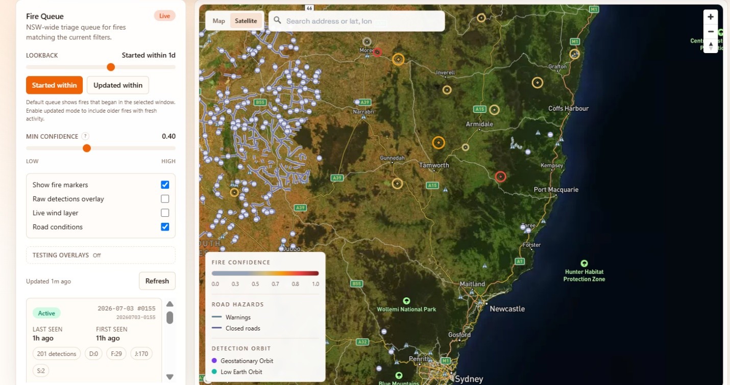
The DeepFire dashboard
During the XPRIZE Wildfire Competition finals in New South Wales, our DeepFire system confirmed fires with 96.2 percent precision and issued roughly a third of its alerts nearly an hour before NASA's FIRMS monitoring service. This section describes how it works and what the result means.
Wildfire is not only a western United States problem. Louisiana's pine forests, coastal marshes, and agricultural fields carry real fire risk, and the conditions that produce large fires, sustained drought, high winds, and dried-out vegetation, are appearing here with greater frequency. Globally, the past decade has seen fires destroy entire communities and release more carbon in a single season than some countries emit in a year. Early detection is the variable that determines whether a fire is contained or becomes a regional event.
DeepFire watches a collection of satellites simultaneously, drawing from weather feeds, thermal anomaly sensors, and Earth-observation imagers. AI fuses this data into a continuously updated picture of fire conditions. When the system identifies the early signature of ignition, it issues an alert immediately, ahead of the processing pipelines that slow down standard government services. Every alert includes an explanation: which satellites flagged the signal, what weather conditions were involved, and which roads or structures lay in the projected fire path.
We evaluated the system under live field conditions during the XPRIZE Wildfire Competition finals, held over New South Wales, Australia in April 2026. DeepFire confirmed 96.2 percent of its alerts as real fires. On close to a third of its confirmed detections, it issued the alert before NASA's FIRMS system, with a typical lead of 53 minutes.
The system also generates risk forecasts 28 to 35 days in advance by combining weather projections, vegetation dryness indices, and terrain data. It was trained on data spanning more than 800,000 square miles across California, Alberta, British Columbia, and Indonesia. To our knowledge, it is among the first systems designed to handle both slow-burning peat fires in tropical wetlands and fast-moving flaming fires in temperate forests within a single framework.
For Louisiana's forestry agencies and emergency management offices, the practical value of long-range risk mapping is the ability to pre-position resources before conditions become critical. The competitive result in New South Wales provides external validation that the system performs under real operational conditions rather than only on curated benchmark datasets.
Forecasting Louisiana's Dead Zone
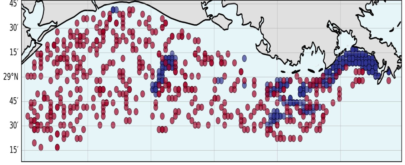
Predicted spots of hypoxia on Louisiana's coast
Every summer a low-oxygen zone forms off Louisiana's coast, forcing marine life to flee or die. We built an AI forecasting system that runs in one second, matches the accuracy of a full physical model, and can rapidly test nutrient reduction scenarios that take the physical model hours to evaluate.
Here is the mechanism. Fertilizer and agricultural waste travel down the Mississippi River each spring and summer. When that nutrient load reaches the Gulf of Mexico, it feeds algal blooms. The blooms decompose and strip oxygen from bottom waters. Fish, shrimp, and crabs either migrate away or suffocate. The low-oxygen zone has reached more than 23,000 square kilometers at its largest extent. The consequences are visible each year in reduced commercial catches and disrupted livelihoods for Louisiana fishing communities.
Accurate forecasting is technically difficult because the zone's size and location depend on how deeply river water stratifies the Gulf water column, how fast bacteria consume oxygen in the sediment, how nutrient plumes shift with coastal currents, and how daily weather disrupts all of these processes simultaneously. Earlier statistical models typically oversimplified these interactions. Full three-dimensional physical models are more accurate but require roughly 1,800 seconds and 518 processor cores to produce a single three-day forecast, making them impractical for rapid scenario testing.
Our team, drawing on oceanography, environmental science, and computer science, developed an alternative published in Scientific Reports in 2025. We trained two AI architectures on 14 years of detailed physical ocean simulations covering the Louisiana-Texas shelf. The resulting system produces the same three-day forecast in one second on a standard computer. Against ship-based field observations collected over 14 summers of Gulf cruises, the AI achieves 67 percent accuracy, a figure that is statistically indistinguishable from the full physical model on the same data. Against the simulation itself, accuracy is 85 percent.
The practical addition is rapid scenario testing. A coastal manager can ask within seconds what would happen to the low-oxygen zone if upstream fertilizer applications were reduced by 20, 50, or 90 percent. Our analysis suggests that reductions exceeding 90 percent of current nutrient loads may be necessary to reach the targets set by the federal Gulf Hypoxia Task Force. That finding has direct relevance for agricultural policy across the entire Mississippi watershed and gives Louisiana a quantitative basis for engaging in those policy discussions.
The model runs quickly enough to support daily operational use, though its predictions are best interpreted alongside physical model output and field observations rather than in isolation.
Monitoring Arctic Permafrost and Its Connection to Louisiana
Permafrost thaw in the Arctic releases carbon that warms the atmosphere, which accelerates ice melt and raises sea levels. Louisiana's sinking coast is unusually exposed to that rise. Our team is tracking permafrost conditions from satellite data to improve the climate projections that inform coastal planning here.
Louisiana communities are already experiencing flooding from tides that would not have reached them a generation ago. The land is sinking while the sea is rising, exposing coastal areas to two compounding sources of flood risk. One significant contributor to sea level rise is a process unfolding far to the north. Permafrost, the frozen ground underlying roughly a quarter of the Northern Hemisphere's land surface, holds an estimated 1.5 trillion tons of organic carbon accumulated over millennia. As Arctic temperatures rise at more than twice the global average rate, that permafrost thaws, releasing carbon dioxide and methane. The additional greenhouse gases warm the atmosphere further, accelerate ice melt elsewhere, and eventually push sea levels higher.
Direct monitoring of permafrost is difficult. The Arctic is vast and remote. Ground stations are sparse and expensive to maintain. Large areas have never had instruments placed in them at all.
Our team addressed this by fusing several types of satellite data: radar imagery that penetrates cloud cover and polar darkness, optical imagery, terrain elevation models, and gravity measurements that detect underground mass changes as ground ice melts. AI trained on the limited available ground measurements extends estimates of permafrost conditions to regions without instrumentation. The result is seasonal maps of permafrost depth and thaw extent covering all of Alaska, with an average forecasting error below two percent relative to physical model output.
That level of accuracy is sufficient to improve the boundary conditions used by global climate models, which in turn affects the sea level projections that Louisiana and other coastal states rely on for long-range planning. The work helps address a monitoring gap that would be difficult for any single federal agency to resolve alone, given the scale of the terrain and the cost of ground-based observation networks.
Identifying Carbon Storage Sites in Louisiana
Louisiana has set a net-zero emissions target for 2050. Carbon capture and underground storage is one of the tools available for reaching it. Our team built an AI-based siting framework that evaluates geological, infrastructure, and equity considerations together rather than separately.
Louisiana possesses several characteristics that make it a plausible candidate for carbon storage at scale: a large industrial base generating substantial CO2 emissions, deep geological formations that have held hydrocarbons safely over geologic timescales, and more than 20 documented injection sites already operating. Thirty-two additional projects are currently under regulatory review. Identifying which sites are actually suitable, however, is a more complex problem than the presence of geological capacity alone suggests.
A viable storage site must meet simultaneous requirements. The subsurface rock must be porous enough to accept injected gas and capped by impermeable layers that prevent upward migration. It must be sufficiently distant from drinking water aquifers. Faults and salt structures that could create unintended migration pathways need to be identified and avoided. And sites should not impose additional industrial burdens on communities that already carry disproportionate pollution exposure. Earlier siting frameworks focused primarily on geological criteria and treated equity as a secondary consideration, which contributed to permitting difficulties and public opposition in several cases elsewhere.
Our team, which includes environmental scientists, geologists, AI engineers, and energy policy specialists from LSU's Center for Energy Studies, built a three-phase framework that evaluates these dimensions together. The first phase produces a region-wide suitability map, drawing on satellite imagery, geological records, EPA environmental justice data, census information, and wetland databases, to score each square kilometer of Louisiana for storage suitability. The second phase matches industrial CO2 sources to candidate storage sites based on pipeline cost and logistics. The third phase conducts detailed subsurface analysis of the highest-ranked candidates. Sites near communities already bearing high industrial pollution loads are deprioritized early rather than filtered out at the end.
A distinctive feature of this framework is its integration of geological suitability, infrastructure economics, and environmental-justice indicators within a single siting process, rather than treating them as sequential filters. Supported by LSU's Institute for Energy Innovation, the framework is now positioned to inform Louisiana's state-level CCuS program.
AI-Assisted Breeding for Drought-Tolerant Rice
Louisiana grows rice. Droughts are becoming more frequent. Conventional breeding programs take years to test which varieties survive dry conditions. We are using AI to read drought-response signals from plant DNA directly, potentially cutting that timeline significantly.
Louisiana rice farming faces increasing climate variability. Droughts are more frequent and less predictable than they were a generation ago, forcing farmers into costly decisions about irrigation, crop variety selection, and field management under greater uncertainty.
The conventional path to drought-tolerant varieties is slow by design. Breeders grow thousands of plant varieties under controlled stress conditions, observe which ones survive or perform well, and then conduct additional cycles of testing to confirm results. The process is rigorous, but it operates on a timescale of years to decades. Climate trends are shifting faster than that pipeline can reliably adapt.
When a rice plant is stressed by drought, specific DNA segments regulate which stress-response genes switch on or off. Those regulatory patterns are encoded in the plant's genome and can, in principle, be read directly without growing the plant through a full stress trial. We trained AI on a dataset of more than 45,000 examples drawn from 13 rice varieties to predict drought gene responses from DNA sequence alone.
The best-performing model predicted drought gene responses correctly about 78 percent of the time. That accuracy is sufficient to meaningfully reduce the number of candidate varieties that breeders need to carry into physical field trials. Varieties that the model predicts will not activate
stress responses effectively can be set aside earlier in the process, concentrating resources on more promising lines.
For Louisiana farmers, the near-term benefit is that improved drought-tolerant varieties could be available sooner than conventional breeding timelines would allow. The longer-term implication is methodological: the same AI approach developed here for rice can in principle be adapted to other staple crops, including wheat, sorghum, and maize, facing similar pressures in food-insecure regions around the world.