AI in Alaska: LSU researchers work to understand permafrost and climate change
April 18, 2023

Department of Environmental Sciences Professor Supratik Mukhopadhyay
BATON ROUGE - Artificial intelligence is proving itself an invaluable tool in many arenas, not the least of which is the fight to understand, plan for and combat the effects of our changing climate. LSU Professor Supratik Mukhopadhyay is currently doing just that, as he and a team of LSU scientists work to develop an AI tool that will help us better understand the degradation of permafrost, the layer of rock or soil beneath the surface that remains frozen year round.
Mukhopadhyay’s goal is for his tool to be able to automatically predict where permafrost degradation is going to take place, something that is not currently well understood. Not only that, “it will be able to predict what are the microbial mechanisms underlying that degradation, and what the impacts on the environment will be,” he said.
Mukhopadhyay has received faculty research grant for this project, from the LSU Provost’s Fund for Innovation in Research. “This seed funding has allowed us to build an interdisciplinary team on this topic and start a collaboration with the US Army Corp of Engineers,” he said.
This team includes Claiborne Gasoline Company Chair in Air Quality/Environmental Toxicology and Chair of the Department of Environmental Sciences, or DES, Chair Kevin Armbrust, and Aixin Hou, Shell professor in Oceanography/Wetland Studies in DES. Jacob Berkowitz of the US Army Corp of Engineers, and an adjunct professor in the Department of Oceanography & Coastal Sciences, and Manas Gartia, an associate professor of mechanical engineering are also included.
Similarities in Soil
At first glance, permafrost might seem an odd topic for researchers in Louisiana. After all, it would be difficult to find a terrain more different from the swampy coast of Louisiana than the permafrost forests of northern Alaska—but appearances can deceiving, and as the effects of climate change are felt around the world, these two very different landscapes are displaying some marked similarities.
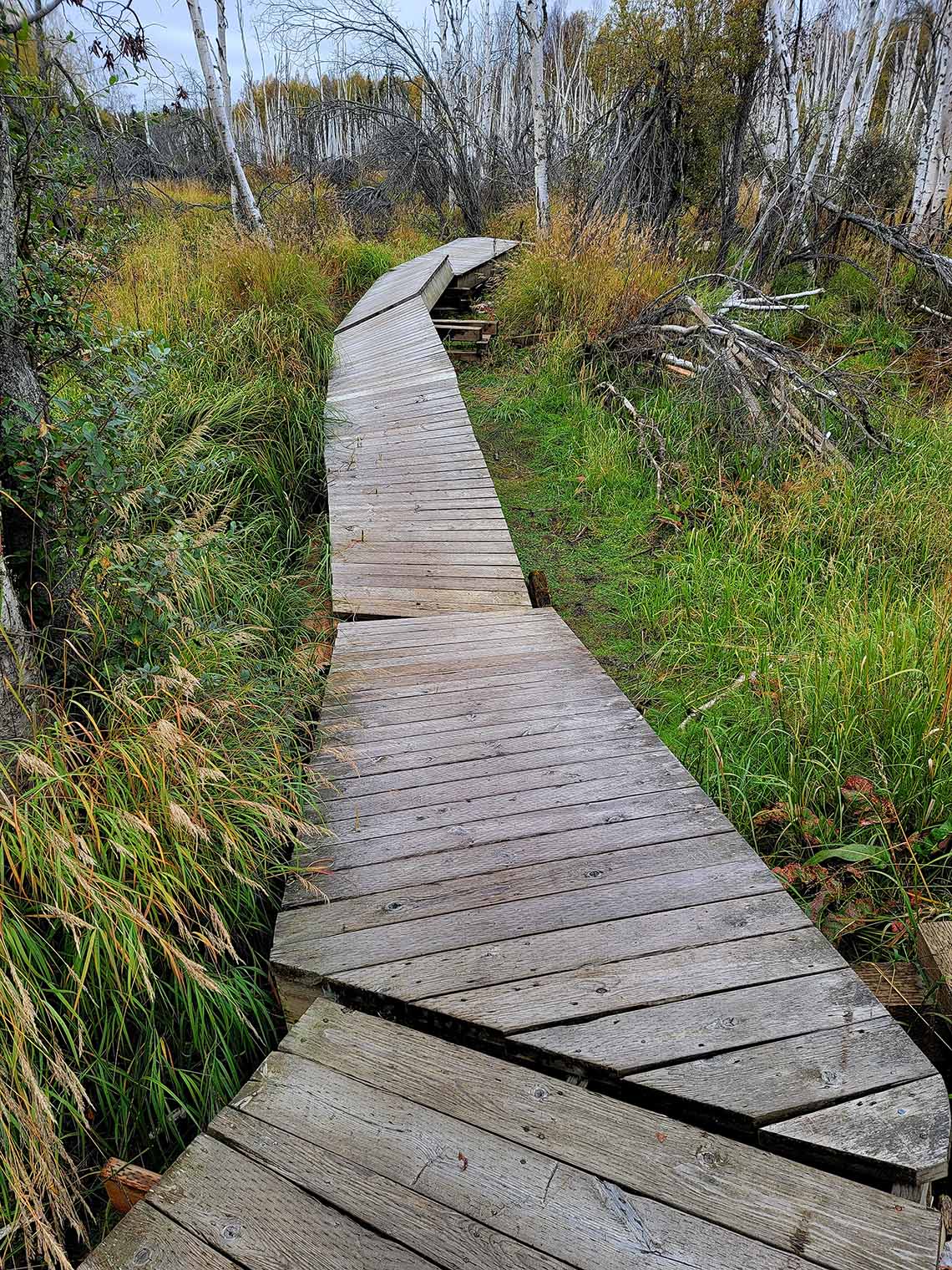
This boardwalk near Fairbanks, Alaska used to be flat, but permafrost melt and the impacts of a drunken forest have caused it to break.
– Photo Credit: Jacob Berkowitz
Mukhopadhyay said the degradation mechanisms occurring in Alaskan permafrost are fairly similar to the subsidence happening Louisiana’s coastal wetlands. Rising sea levels are a common factor as well.
“The permafrost zone of Alaska and the coastal region of Louisiana are characterized by soils composed of organic matter that, when disturbed, induce rapid vegetation die-off, structural failure, collapse, and conversion to open water,” said Berkowitz.
Visual evidence of these phenomena is obvious in both places. Coastal Louisiana is home so-called ghost forests, stands of dead cypress trees, marking places where intruding salt water has subsumed the sinking wetlands. Likewise, Alaska is home to the so-called drunken forest, stretches of trees now bent over and akimbo as the soil defrosts and sinks beneath their roots, killing them.
These changes have a larger consequences as well. As Louisiana’s sinking wetlands release carbon and methane into the atmosphere as they are subsumed, so the permafrost threatens to release its carbon dioxide—more than humanity has produced since the industrial revolution—into the atmosphere.
“Arctic Alaska and coastal Louisiana are some of the most vulnerable and important landscapes in a climate change context,” Berkowitz said. “This sort of research will improve our understanding of ecological outcomes resulting from our rapidly changing climate and associated consequences for societies capacity for natural resource utilization in the future.”
A New Tool for Understanding
Currently, not much ground-level data on the degradation of permafrost is available. Most current information comes from remote sensing imagery, which can’t always shed light on the full picture of where the next patches of degradation will be, or what the conditions are that aggravate it.
Researchers on this project will be using soil samples gathered by the Army Corps of Engineers and using AI to design experiments to conduct on them, in order to better understand the mechanisms behind permafrost degradation. The information gleaned from that process will then be combined with the remote sensing data, to create a tool that will be able to use satellite imagery to find “unseen sites” area where permafrost degradation may be occurring.