X Marks the Spot: LSU Center for GeoInformatics Acquires Absolute Gravimeter
 BATON ROUGE – Since its inception in 2002, the LSU Center for GeoInformatics (C4G)
has worked with local, regional, state and federal partners to identify the impact
of subsidence, the underlying cause of coastal land loss and flooding in Louisiana.
BATON ROUGE – Since its inception in 2002, the LSU Center for GeoInformatics (C4G)
has worked with local, regional, state and federal partners to identify the impact
of subsidence, the underlying cause of coastal land loss and flooding in Louisiana.
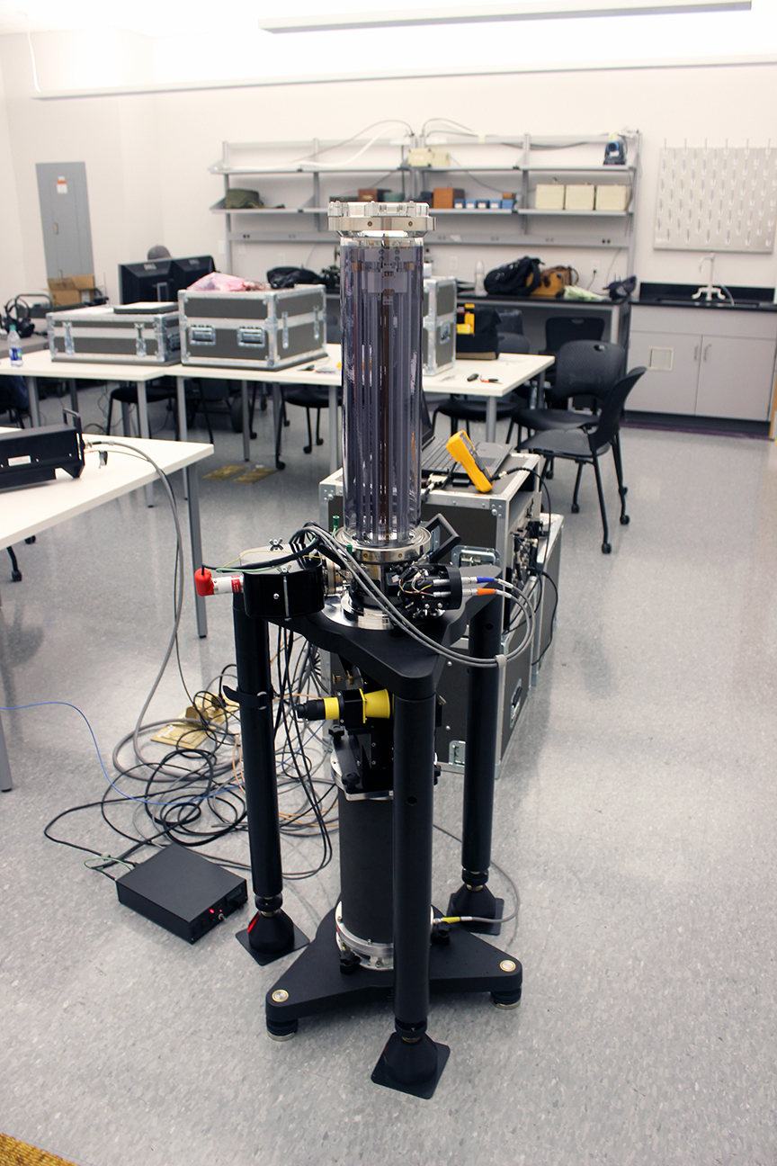
In order to engineer effective solutions for preserving life and property, the center has acquired a new piece of equipment used to measure gravity—the FG5-X Absolute Gravimeter, the only one of its kind in the southeastern United States.
LSU Civil and Environmental Engineering Senior Instructor Cliff Mugnier, who teaches surveying, geodesy and photogrammetry, said the new gravimeter will be used for determining the acceleration of gravity at a particular spot.
“The center measures GPS,” Mugnier said. “We establish antennas, bolt them to buildings all over the state and northern rim of the Gulf of Mexico, from Corpus Christi to Jacksonville. The GPS instruments that we have there are used for measuring latitude and longitude for building highways and various construction work, as well as for elevation.
“The problem with GPS is it really doesn’t determine elevation. It determines a height. That’s a big deal because when we do elevations for flood insurance, you need the elevation of the lowest floor of your house. To go from height to elevation, you have to know what the gravity field is. That’s what the gravity meter is for.”
The Absolute Gravimeter, which cost $400,000 and was acquired with money through the self-funded center, will help C4G with its Real-Time Network (RTN) program. The RTN service has subscribers from all over the South who need gravity measured where they have antennas installed. There are currently 60 buildings in the state and another 60 to 70 in the South that LSU controls and observes.
“Other people may own the buildings, but they give LSU access for their receivers,” Mugnier explained. “When engineers and surveyors go surveying, they need two pieces of GPS equipment, which ties up $40,000. Or they can have just one to do their surveying, a cell phone, and a subscription to LSU, who will tell them what the corrections are. So, they save major bucks. The money we get from the subscriptions supports the center and buys our equipment.”
Mugnier said that in other states, GPS is funded with tax dollars, leaving little money left for research. Because LSU C4G is self-funded through its subscription service, the center is able to do additional research to further support the state.
“The problem in Louisiana is that it is in a crustal motion area because of subsidence,” Mugnier said. “The [federal government] doesn’t have enough money to do the very detailed work in Louisiana and that’s where we come in. Louisiana needs more precise information for flood elevations and how fast we’re subsiding in different areas, along with the rate change,” Mugnier said.
C4G has already conducted surveys through funding from the legislature to determine the elevation of all of the state’s evacuation highways.
“As they continue to subside, when a hurricane is coming, planners need to know the elevations of the highways and how many hours they need ahead of time to evacuate people,” Mugnier said. “All of this revolves around what we’re doing with respect to elevation, gravity research and support of GPS surveying.”
Like us on Facebook (@lsuengineering) or follow us on Twitter and Instagram (@lsuengineering).
###
Contact: Libby Haydel
Communications Specialist
225-578-4840