Open Water, Artificial Intelligence: Using AI To Understand Turbulence in the Upper Ocean
June 14, 2023
Approximately the top 100 meters of ocean water is known as the ocean surface boundary layer.

Associate Professor of Oceanography & Coastal Sciences Junhong Liang
BATON ROUGE - The ocean surface boundary layer, which can stretch to the top hundred meters or so of ocean water, is the most visible and accessible to humans. However, despite its proximity, conditions in this area pose a big challenge to researchers looking to provide accurate forecasts through modeling.
But Department of Oceanography & Coastal Sciences Associate Professor Junhong Liang and his team will be using artificial intelligence to change that. Liang, who also holds a joint appointment at the Center for Computation and Technology, along with Florida State University’s Distinguished Professor of Oceanography Eric Chassignet and a team of researchers, has received funding from the Office of Naval Research to build an AI module that can generate a more precise prediction of the upper ocean into the HYCOM system, or Hybrid Coordinate Ocean Model system.
The HYCOM system is widely used in the research community, and by the US Navy, which issues both “nowcasts”—reports on current ocean “weather”—as well as daily and 7 day forecasts. This information is not only used to direct Navy fleet operations, but is also made publicly available to the community.
The HYCOM system is run by the HYCOM consortium, a multi-institutional organization whose goal is to develop a fine scale, three dimensional model of the ocean state that runs in real time. It is sponsored by the National Ocean Partnership Program.
The upper ocean frequently experiences turbulence, or fine-scale, chaotic ocean currents, said Liang. Turbulence cannot be directly simulated by operational ocean models, but its impact is large enough that its effects must be approximated in those models. Currently, the development of physics-based approximations of these conditions has bottlenecked, Liang said. “We are hoping that the data-based AI model will make the breakthrough.”
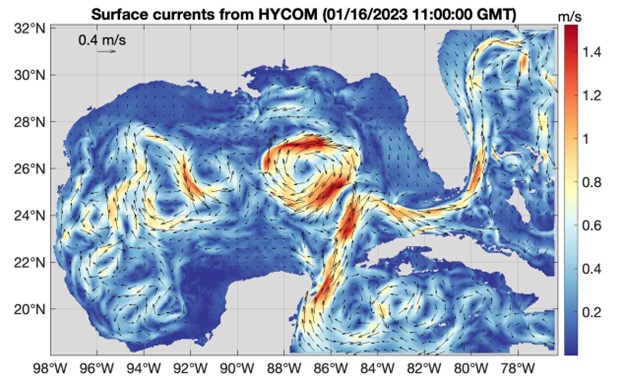
A map of surface currents generated by HYCOM, the Hybrid Coordinate Ocean Model System
Liang noted that the AI module will improve the simulation of upper-ocean temperature and salinity of the HYCOM system. The new module will also improve hurricane forecasts and allow for more accurate acoustic sensing in the ocean. Sound waves are widely used in ocean exploration, and their propagation is controlled by upper-ocean temperature and salinity, which the module, when completed will help forecasters better predict.
Liang and his team plan to build the AI framework in the HYCOM system and then test it for the Gulf of Mexico. “The Gulf is a good choice for testing the novel framework because of its limited extent and abundant data,” he said. It also holds a strategic importance for industry and the severe weather it often experiences also means forecasters need accurate models.
However, Liang said the framework, when completed, could be applied to the ocean anywhere on the globe.