Mineral Recovery Impacts and Coastal Land Loss
March 07, 2022
Excerpt from From Air to Land to Sea: 50 Years of Educating Coastal Leaders (publication forthcoming)
By Gene Turner
Flying over the coast you can see what is not visible from a small boat many fish from – miles and miles of man-made canals and waterways dug mostly for oil and gas recovery. There were no satellite photos to use when students like Don Davis and Judy Monte in the LSU Department of Geography & Anthropology wrote dissertations on them, just before the Department of Marine Sciences (DMS) was created. Davis wrote presciently (1973) that “Louisiana’s coastal area is criss-crossed, ringed, cut and otherwise dominated by a massive grid of man-made canals. Interest, time, technology, and population characteristics have changed, but canals endure, many for over 150 years. Their influence continues to have a decisive and cumulative impact on the wetlands environment.”
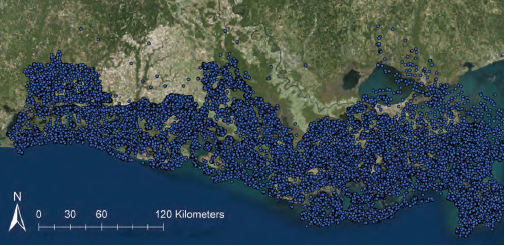
The blue dots are for all permitted drilling wells in the 14 coastal parishes from 1901 through 2017. Thirty-six percent of the 76,247 permits were on (wet)land and were officially abandoned and plugged.
– G. McClenachan
The DMS began under the Center for Wetland Resources whose first director, Jack Van Lopik, implemented the Louisiana Sea Grant Program. He said (1955), “Many oil company canals, with their flanking spoil banks, cross the marsh giving rise to changes in drainage, hence, vegetation. Although the trappers of the region are probably prone to exaggerate the effects of such canals on the vegetation of their trapping lands, there can be no doubt that changes do occur as a result of their construction. In addition, artificial levees dam many streams and cause modification of drainage...Thus, relatively minor modifications in marshland drainage may create many unforeseen problems.”
These comments were similar to those of the director of Louisiana Wildlife and Fisheries, Lyle St. Amant, who said (1972), “…pipeline canals traversed marshlands and embayments without regard for changes in natural drainage pattern. Also disregarded were resultant disruption of currents in bays and water flow in marshlands and the direct loss of animals and plants within the right-of-way. The long-range effects of such canals involve accelerated erosion of unstable marshes.”
The newly-formed DMS soon had faculty, students, and research staff quantifying these qualitative field-based observations. Dr. Woody Gagliano had just finished making the first measurements of Louisiana’s coastal land loss when the DMS was founded, and he included measurements of canal density, as had Don Davis. Faculty and students such as Nancy Craig, Bill Scaife, Aaron Bass, Jim Gosselink, Jim Lee, Erick Swenson, and Gene Turner soon made quantitative connections between the spatial density of canals and coastal land loss starting with a landscape view of where canals were and were not, and where land loss was or was not. Recent compilations by Giovanna McClenachan and Turner showed that there was a spatial and temporal aspect to this that was tied to permits issued by the state and federal agencies. Today, the length of canals crossing Louisiana’s coast is longer than the distance to go from New Orleans to London and back; the length of dredged spoil material piled up on both sides of the canal is twice that length. The spoil banks might be 1-3 m (3-9 ft) high, which is much higher than the normally 30 cm (1 ft) tides; and so spoil banks and canals redirect water in and out of the coast on a massive scale, piece-by-piece. New ponds and lakes were more likely to form where spoil bank density was relatively high, and a higher percentage of ponds were likely to become marsh where there were few spoil banks (Yeleswarapu, Rao, and Turner).
Cause-and-effect explanations for these quantitative relationships were becoming understood with field-based studies by people in the DMS such as Irving Mendelssohn and Karen McKee (flooding tolerance), Ron Delaune and Don Cahoon (sedimentation), and Gene Turner (induced subsidence). Various groups outside of LSU were also part of understanding these factors (esp., Robert Morton, United States Geological Survey). A major study of the effects of oil and gas canals on land loss in 1987 was sponsored by the New Orleans office of the Minerals Management Service (MMS, now Bureau of Ocean Energy Management). The MMS study involved more than a dozen scientists from many disciplines, mostly from the DMS, and found that 16% of the wetland losses from 1955 to 1978 were directly due to canals turning marsh to open water and spoil banks converting wetland to shrub/scrub habitat. Their consensus estimate was that the total impacts of canals and spoil banks on wetland losses from 1955 to 1978 were between at least 30 to 60% of all losses. The infrastructure supporting Outer Continental Shelf oil and gas extraction activities was estimated (Bob Baumann) as being from 8 to 17% of the total wetland loss.
Objections are made about these observations by ignoring, passive resistance, or offering contrary arguments. These objections were often about the influence of geological faults, levees on the Mississippi River, fluid withdrawal, and who might end up paying for restoration. Legal remedies have been proposed that identify a way to fill in canals and de-construct spoil banks. So far, however, fewer than about 50 of the dry well locations have been filled in out of the 27,483 permitted locations on land that were dry or abandoned by 2017. Using hovercraft for exploration, as was being done in Alaska, was proposed by Walt Sikora as a way to avoid dredging but not pursued as an alternative.
The frequency of dredging wetlands is receding as mineral recovery rates decline after the peak from 1955 to 1965 when 29% of the permits had been issued as of 2017. There are consequences for the way the oil and gas was recovered from deep underground that are now apparent. An increased sea level rise will stress wetland plants in another way that will soon cross a ‘tipping point’ of inundation causing catastrophic losses. The Center for Wetland Resources building that existed when the DMS was founded may later become a beach, 17 feet above today’s sea level, as the world’s sea level and temperature rises. Successful wetland restoration and management requires considerations of these legacies and futures—and technical knowledge. The newer faculty will be part of this mission, which is an essential core goal for the department, LSU, and the state.